|
Today was the departure day we had long waited for.
In the morning, we contacted a pilot and carried our luggage into the airport.
We loaded our luggage into a helicopter, and soon after we set off for the expedition.
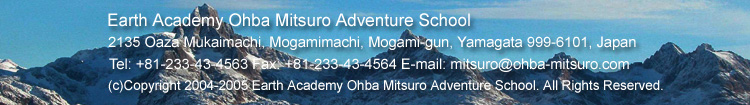
Making arrangement with the pilot, Arne, before the departure
It was decided that we we had to make two flight trips as there were lots of luggage to transport.
Mr. Nagatani and I boarded the helicopter on the first flight and flew to the ice cap.
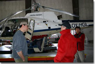
During the flight, we saw glaciers in mountain valleys.
The light blue glaciers were so stunning that it masked the dangerous scenery created by the crevasses.
The glacier I saw from the helicopter
Its beauty was beyond description
The ice cap appeared in sight as we flew over a mountain.
As far as I could see, everything was just white and flat,
and I started to lose my sense of direction and distance.
I had never experienced such a strange feeling.
The landing point was 61° 34′ 48″ N, 45° 47′ 60″ W.
We unloaded and waited an hour for Miyashita-san.
As we waited, snow started to fall, and the visibility worsened slightly.
After she arrived, we unloaded the luggage from the helicopter.
She couldn't stay much because of the bad weather, so she left immediately afterwards.
After they left, we sorted out the luggage and loaded it onto sleds.
Our progress was hindered by the deep snow and the heavy loads we had (110kg each).
We did not achieve as much as we had planned.
Besides, the weather was too bad to make the move.
Since today was the first day of the expedition.
we decided not to push ourselves too much.
We moved about 200m and set up a tent.
Even in the tent, we had much to do.We began by starting the stove.
We had to melt the snow to boil some water so we could have some coffee or tea to warm the body and take a short break.
We repeated this process several times to have enough hot water in a pot for later use.
Next, we made a call to Miyashita-san at base camp by Iridium satellite phone to obtain any inportant information.
We then checked our location by GPS, made an entry in the diary,
and sent e-mails by Inmarsat satellite phone.
And finally had a meal.
The food we are carrying for this expedition is called pemmican,
a high-calorie food for polar expeditions,
which was specially produced by Ms. Araki of Seitoku Junior College of Nutrition,
Meiji Shokuhin, and Meiji Seika Kaisha. For the mornings and evenings,
we eat pemmican containing well-balanced, freeze-dry meat and vegetable with hot water.
And for lunch, because we are on the move in the daytime, we have pemmican that can be taken easily.
This is chocolate-based and contains sesames, pine nuts, sun-dried raisins, etc.
After supper, I brush teeth and go to sleep. This is my typical day on the ice cap. Now, good night, everyone!
Recollection of the departure day (April 5) written on April 7
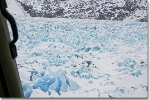
We stayed for 6 days in Narsarsuaq, a town located in southern end of Greenland,
and made all the necessary preparations.
Then on April 5 we were able to depart for the expedition.
We carried sleds, tents, sleeping bags, food,
and communications equipment from the Youth Hostel and loaded them into a trailer.
We drove to the airport, which was just a 3-minuite drive from the Youth Hostel.
It was a fine day, and the snow capped mountain was clear and shining in the blue sky.
In front of the youth hostel on a sunny day
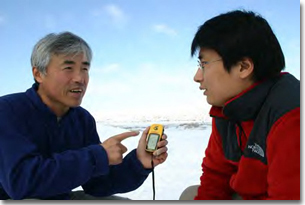
Discussing with Mr. Nagatani before departure
We removed a seat of the helicopter to load the luggage, and Nagatani-kun and I climbed aboard the helicopter.
When I fastened the seat belt and wore headphones that enabled me to communicate with the pilot,
a feeling of tension arose. For the first flight, Nagatani-kun and I flew to the starting point on the ice cap.
Bellow our eyes were saw-edged glaciers winding through valleys of rugged mountains and extending itself toward the sea.
It was beautiful, and scary.
When the helicopter arrived at the southern end of the ice cap,
I could see the whitest snow covering the entire area toward the horizon.
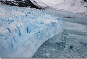
Glacier winding through the valley of rugged moutain toward the sea
Here we were finally on the ice cap.
Soon after we and the luggage were dropped off,
the helicopter flew back to the airport to pick up Miyashita-san,
the base camp manager, and the rest of equipment.
About 100m from where we were, t
here stood was a 200m-tall nunatak (a mountain peak appearing above the surface of ice cap) showing its black rock surface.
Since this mountain is about 2,222m tall, we are currently at a height of 2,000m above sea level.
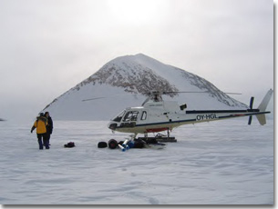
At the starting point (2000m in height above sea level)
Behind is a 222m-tall nunatak
We waited about one hour, and there came the helicopter carrying Noriko-san.
We unloaded the luggage and took some pictures.
But the helicopter hastily flew away with Noriko-san on board due to a sudden change in weather.
Because a helicopter flies by contact, checking where the snow surface lies,
if the borderline between the snow and the sky is not visible, it is too dangerous to make the flight.
Nagatani-kun and I loaded the equipment on each sled,
put seals on skis, and tried to drag the sleds.
But it was too heavy to move the sleds.
The snow was soft and deep, and the 110kg sled just sank into the snow.
All this is due to a high temperature (-1 degree Celsius) and a week wind,
not allowing the snow to get hard.
At 61° 34′ N at such a high altitude (2,000m),
I had never imagined that the temperature could be this high.
Today we dragged the sleds about 200m and set up a tent.
In the beginning of an expedition,
it is important to go slowly and be patient until the body and mind get used to the local environment.
Mitsuro Ohba
|